Trip Facts
Country:
Nepal
Duration:
16 Days
Max Altitude:
Thorong La pass, 5,416 m (17,769 ft)
Activities:
Trekking and a high pass crossing
Region:
Annapurna (Annapurna Conservation Area)
Starting Point:
Kathmandu
Ending Point:
Kathmandu
Grade:
Strenuous
Group Size:
2 to 12 trekkers (private and custom departures available)
Accomodation:
Teahouses on the trail, 3-star hotels in Kathmandu and Pokhara
Best Season:
Mar-May & Sep-Nov
Notice
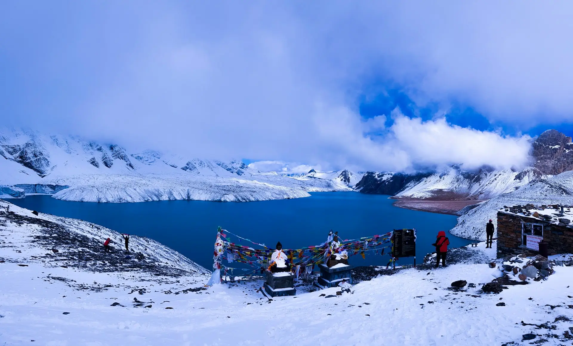
This trek adds a side trip to Tilicho Lake (4,919 m), one of the highest lakes in the world, to the classic Annapurna Circuit. So you get the lake and the pass in one trip.
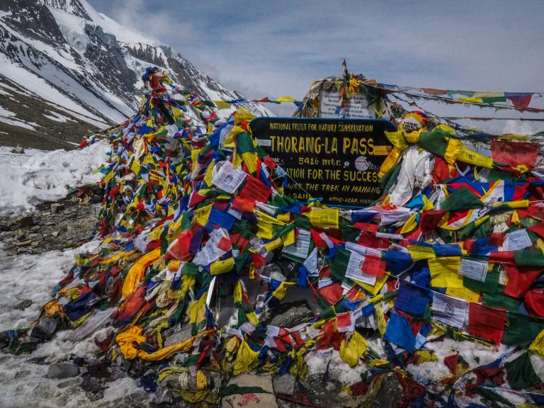
The high point is the Thorong La pass (5,416 m), crossed on Day 10. You then drop to the holy temple of Muktinath (3,800 m).
It is a strenuous trek with long, high days. So it suits fit trekkers with some experience. A licensed guide and permits are required, and Spade Himalaya arranges both.
Overview of Annapurna Circuit with Tilicho Lake Trek 16-Days
Quick answer: The Annapurna Circuit with Tilicho Lake Trek is a 16-day trek in Nepal’s Annapurna region. It adds a side trip to Tilicho Lake (4,919 m), one of the highest lakes on earth, to the classic circuit over the Thorong La pass (5,416 m). It is graded strenuous, and it needs an ACAP permit, a TIMS card, and a guide (Nepal Tourism Board, retrieved 2026-06-30).
The Annapurna Circuit with Tilicho Lake Trek is a 16-day journey that adds a jewel to the classic circuit. Tilicho Lake sits at 4,919 m, in a high basin below the Grande Barrier. So it is one of the highest lakes in the world, and its turquoise water is unforgettable. This trek reaches the lake, then rejoins the main trail over the Thorong La pass.
The route follows the classic Annapurna Circuit for the first days. First, you drive to Chame, then walk up the Marsyangdi valley through Pisang. Then you reach Manang (3,540 m), a Tibetan-style town below the Annapurna peaks. So you take a rest day here to explore and adjust to the height.
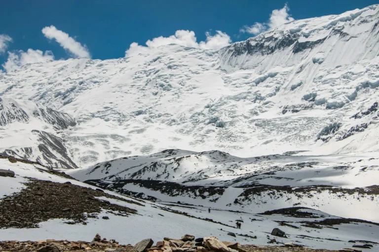
From Manang, the trail branches off to Tilicho. You walk through Khangsar to Tilicho Base Camp (4,150 m), on a wild, exposed path. Then you climb to the lake at 4,919 m, with the ice wall of the Grande Barrier behind it. After the lake, you rejoin the circuit at Yak Kharka. So you cross the Thorong La pass (5,416 m), the high point of the trek. On the far side, you drop to the sacred temple of Muktinath, then fly out from Jomsom.
This trek is graded strenuous. It reaches 5,416 m, adds the high Tilicho detour, and has several long days. So you need good fitness and ideally some trekking experience. The plan builds in a rest day at Manang and a slow, steady climb. Spade Himalaya runs this trek with licensed Nepali guides. So your guide sets a safe pace, watches the weather, and checks your health each day.
Prefer a shorter trip? Then see the classic Annapurna Circuit Trek in 12 days. For a fuller cultural version, see the Annapurna Circuit via Thorong La Pass. For a lower, easier trek, see the Annapurna Base Camp Trek. For a remote add-on nearby, see the Nar Phu Valley Trek, or read our Annapurna region trekking guide.
Trips Highlights
- Hike to Tilicho Lake (4,919 m), one of the highest lakes in the world.
- Cross the famous Thorong La pass (5,416 m), the high point of the trek.
- Visit the sacred temple of Muktinath (3,800 m), holy to Hindus and Buddhists.
- Walk the classic Annapurna Circuit, from green valleys to high desert.
- Rest and explore the Tibetan-style town of Manang (3,540 m).
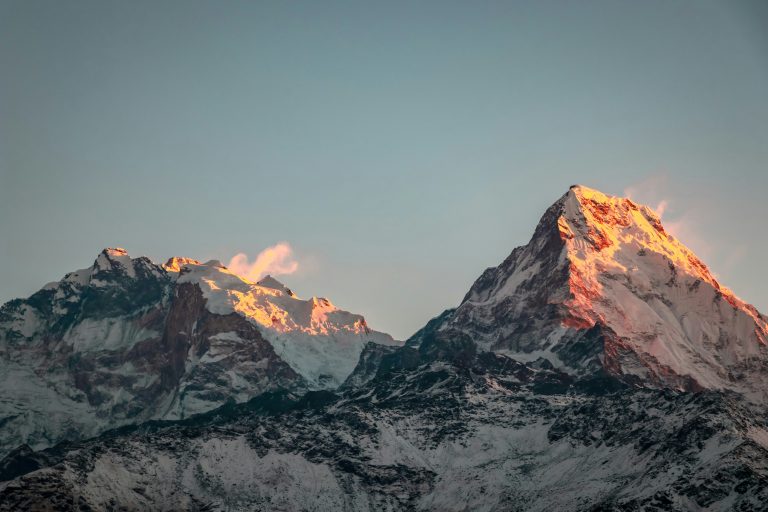
- See Annapurna III, Gangapurna, Tilicho Peak, and the Chulu peaks up close.
- Trek below the huge Grande Barrier, a wall of ice above Tilicho Lake.
- Cross into the dry, Tibetan world of the upper Kali Gandaki.
- Enjoy apple pie and apple brandy in the Thakali village of Marpha.
- Finish with a scenic mountain flight from Jomsom to Pokhara.
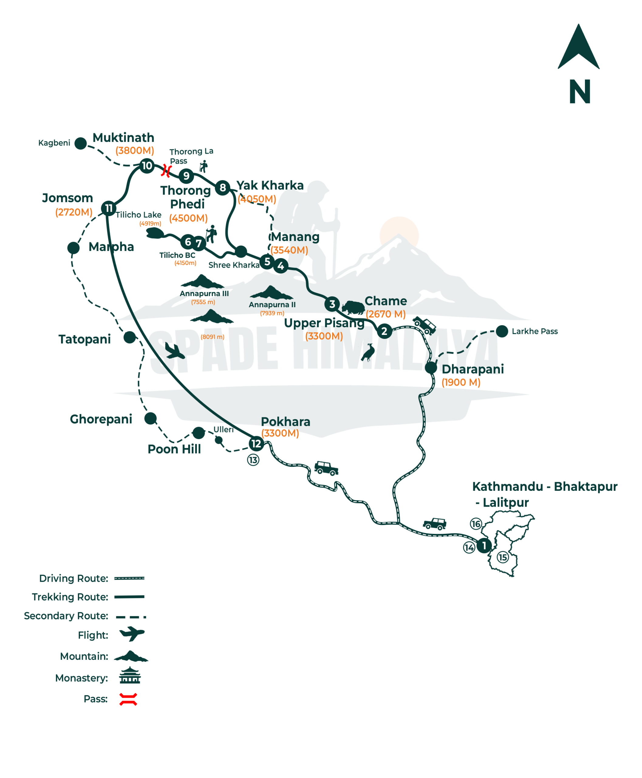
Kathmandu (1,400 m) → drive to Chame (2,670 m) → Upper Pisang (3,300 m) → Manang (3,540 m) → Tilicho Base Camp (4,150 m) → Tilicho Lake (4,919 m) → Yak Kharka (4,050 m) → Thorong Phedi (4,450 m) → Thorong La pass (5,416 m) → Muktinath (3,800 m) → Jomsom → fly to Pokhara → Kathmandu.
In short, you drive to Chame and walk up to Manang. Then you detour to Tilicho Lake and back to the circuit. After that, you cross the Thorong La pass to Muktinath. Finally, you fly from Jomsom to Pokhara and travel on to Kathmandu.
Trips Itinerary
A Spade Himalaya representative meets you at the airport and drives you to your hotel in Thamel, about thirty minutes from the terminal. Everything on this trip runs by road at the start, beginning with a long jeep day west tomorrow and up the Marsyangdi valley.
Kathmandu is at 1,400 m, so there is no height to manage yet. Your guide runs the full briefing in the late afternoon and checks your gear. Bring your passport, two photographs and a copy of your insurance, because the trekking permits need all three.
- Duration: about 30 min drive
- Max Altitude: 1,400 m
- Accommodation: 3 star hotel (Shared)
A long day by private jeep, following the highway west along the Trishuli and Marsyangdi and then climbing the rough mountain road up the valley to Chame.
Chame is at 2,670 m and the drive covers about 230 km in nine or ten hours. The sealed road ends past Besisahar and everything beyond it is slow going. Chame is the district headquarters of Manang and has a small hot spring by the river.
- Duration: 9 to 10 hrs drive(230 km)
- Max Altitude: 2,670 m
- Meals: Breakfast, Lunch & Dinner
- Accommodation: Guest House
The trek begins in earnest. You walk through pine forest beside the Marsyangdi, under the huge curved rock face of Paungda Danda, and climb steadily to Upper Pisang.
Upper Pisang is at 3,300 m, about 14 km in five or six hours for a gain of some 630 m. It is a solid first walking day but not a punishing one, and the pace stays comfortable.
Paungda Danda rises straight out of the valley and is worth stopping for. Annapurna II and Pisang Peak come into view as you climb, and Upper Pisang is a stone village with an old monastery.
- Duration: 5 to 6 hrs walk (14 km)
- Max Altitude: 3,300 m
- Meals: Breakfast, Lunch & Dinner
- Accommodation: Guest House
Today you take the high route to Manang through the villages of Ghyaru and Ngawal rather than the valley path, which is more work and gives far better views.
Manang is at 3,540 m, about 17 km in six or seven hours. The upper trail climbs well above the river before dropping back down, so you gain far more than the net figure suggests.
Annapurna II, III and IV and Gangapurna stand across the valley for the whole walk. You pass old chortens and mani walls on the way, and Manang is where you stay two nights.
- Duration: 6 to 7 hrs walk (17 km)
- Max Altitude: 3,540 m
- Meals: Breakfast, Lunch & Dinner
- Accommodation: Guest House
You stay a second night in Manang and spend the day walking high above it, because an active rest day is what actually gets your body ready for the pass.
Most groups climb toward Ice Lake at around 4,600 m or to a nearer viewpoint, seven kilometres and three to five hours, then come back down to sleep at 3,540 m.
From up there you look across Gangapurna, Annapurna III and the Gangapurna lake below. Manang has an old gompa, a small mountain museum and a free altitude talk worth attending.
- Duration: 3 to 5 hrs hike (7 km)
- Max Altitude: 4,600 m
- Meals: Breakfast, Lunch & Dinner
- Accommodation: Guest House
You leave the main circuit today and head for Tilicho, walking through Khangsar and then out onto a wild, exposed hillside high above the valley floor.
Tilicho Base Camp is at 4,150 m, about 16 km in six or seven hours. The climb is not steep but the crossing is a long one and the ground underfoot is loose in places.
That hillside is known for landslides, so your guide leads and the group crosses the worst of it together and without stopping. Khangsar is the last real village on the route.
- Duration: 6 to 7 hrs walk (16 km)
- Max Altitude: 4,150 m
- Meals: Breakfast, Lunch & Dinner
- Accommodation: Guest House
The day you came for. You start early before the wind rises, climb the switchbacks above base camp, spend time at the lake and come back down the same way.
Tilicho Lake sits at 4,919 m, which is around 770 m of climbing, and the round trip of 13 km takes six or seven hours. The air is thin, so it is slow work all the way up.
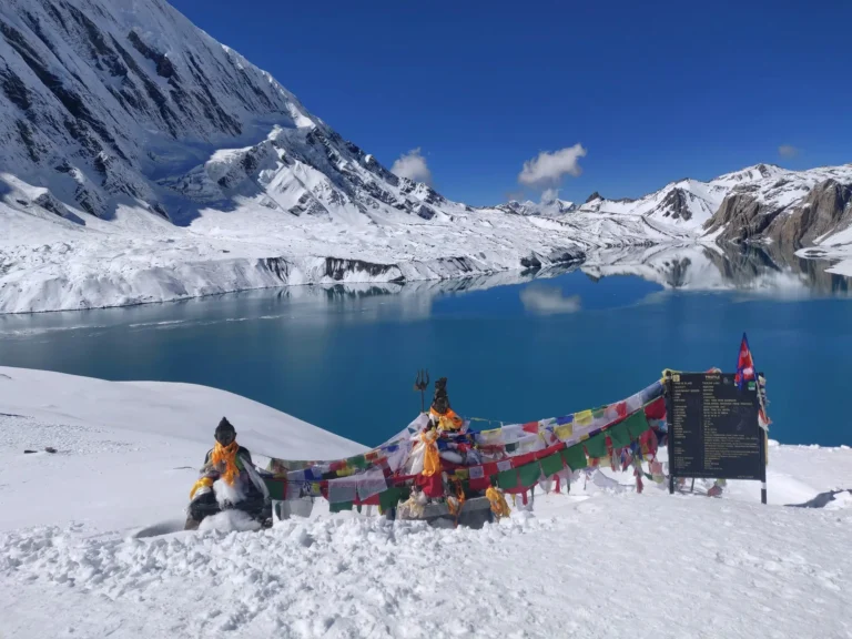
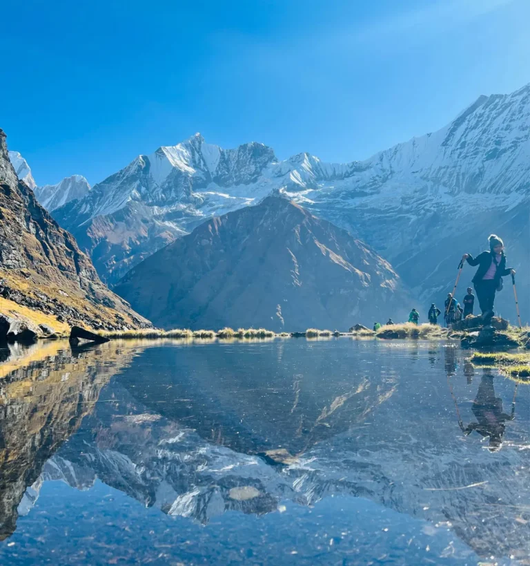
This is one of the highest lakes of its size anywhere in the world, and the turquoise water sits right below the long ice wall of the Grande Barriere.
The silence up there is the thing people remember rather than the view. Almost nobody else is around, and the lake is frozen solid for much of the year.
- Duration: 6 to 7 hrs round trip (13 km)
- Max Altitude: 4,919 m
- Meals: Breakfast, Lunch & Dinner
- Accommodation: Guest House
You rejoin the main circuit today, retracing part of the route back toward Khangsar and then branching onto the higher path that runs through Shree Kharka.
Yak Kharka is at 4,050 m, about 15 km in six or seven hours. The net height change is small but the trail rolls up and down across the hillside all day. These open grassy slopes are grazed by yaks, and blue sheep are often on the rocky ground above the path.
- Duration: 6 to 7 hrs walk (15 km)
- Max Altitude: 4,150 m
- Meals: Breakfast, Lunch & Dinner
- Accommodation: Guest House
A short day that gets you into position for the pass, climbing gently along the valley and then crossing the river on a small bridge to the lodges at Thorong Phedi.
Thorong Phedi is at 4,450 m, only seven kilometres and three or four hours away. Short stages at this height are how you arrive at the pass in good condition.
Phedi means foot of the hill, which is exactly what it is. The trail crosses a landslide prone section where your guide picks the line, so stay close and keep moving through it.
- Duration: 3 to 4 hrs walk (7 km)
- Max Altitude: 4,450 m
- Meals: Breakfast, Lunch & Dinner
- Accommodation: Guest House
The big day. You leave before dawn in the cold and dark, climb the long trail to the prayer flags on the Thorong La, then make the long descent into Mustang.
The pass is 5,416 m and Muktinath is at 3,800 m, about 16 km across seven to nine hours. That is nearly 1,000 m up and more than 1,600 m down in a single day.
You leave that early so that you cross before the wind rises, which it does most mornings once the sun has come up properly onto the top of the pass itself.
Poles make a real difference on the long rocky descent, and the view from the top of the pass runs in every direction with nothing at all in the way of it.
- Duration: 7 to 9 hrs walk (16 km)
- Max Altitude: 5,416 m
- Meals: Breakfast, Lunch & Dinner
- Accommodation: Guest House
You visit the Muktinath temple in the morning, then head down the dry, windy valley toward Jomsom, on foot or by jeep depending on how the group feels.
Jomsom is at 2,720 m, about 20 km and four or five hours of walking and driving combined. The wind here reliably picks up by late morning, so an early start helps.
Muktinath is sacred to Hindus and Buddhists and has 108 stone water spouts and an eternal flame. On the way you pass Kagbeni, a walled village at the gateway to Upper Mustang.
- Duration: 4 to 5 hrs walk & drive (about 20 km)
- Max Altitude: Muktinath 3,800 m
- Meals: Breakfast, Lunch & Dinner
- Accommodation: Guest House
An early flight from Jomsom down to Pokhara, and it is one of the more spectacular short flights anywhere, following the gorge between two 8,000 m peaks.
The flight takes about twenty five minutes and drops you from 2,720 m to 822 m. Mountain flights go early because the valley wind makes later departures unreliable.
You fly down the Kali Gandaki, one of the deepest river gorges in the world, with Dhaulagiri on one side and Annapurna on the other. Pokhara is green, warm and beside a lake.
- Duration: about 25 min flight
- Max Altitude: 2,720 m
- Meals: Breakfast Included
- Accommodation: Star Hotel (Shared)
A free day in Pokhara, and it sits in the itinerary partly as a buffer, because mountain flights out of Jomsom are genuinely weather dependent in every season.
If the schedule has run to plan, the whole day is yours. You can row out on Phewa Lake to the Tal Barahi temple, go up to the World Peace Pagoda for the view, shop for gifts, or do very little at all beside the water.
- Max Altitude: 822 m
- Meals: Breakfast included
- Accommodation: Star Hotel (Shared)
You drive back to Kathmandu today, retracing the river valleys and the hill towns, and arrive in the afternoon with time to shower and rest before the evening.
The drive takes about six hours and climbs from 822 m back to 1,400 m. There is a farewell dinner with the team in the evening, which is a good chance to settle tips and swap photographs with your guide.
- Duration: 6 hrs drive
- Max Altitude: 1,400 m
- Meals: Breakfast included
- Accommodation: 3 Star Hotel (Shared)
Today is a spare day held in reserve, and it is here because flights and mountain roads in this region genuinely do run late from time to time in any season.
If everything has gone to plan, the day is entirely free. Bhaktapur and Patan are both worth a half day for their squares, temples and workshops, Thamel is good for gifts, and resting at a cafe is a perfectly reasonable alternative.
- Max Altitude: 1,400 m
- Meals: Breakfast included
- Accommodation: 3 Star Hotel (Shared)
Your trip ends today. The morning is free for any last shopping, then a representative drives you to the airport, about thirty minutes from Thamel though traffic can stretch it. You leave with Tilicho Lake and the Thorong La behind you.
- Max Altitude: 1,400 m
- Meals: Breakfast included
Trips Include
- All airport transfers in a private vehicle.
- 5 nights' hotel in Kathmandu and Pokhara (3-star, twin share) with breakfast.
- Tourist bus or flight between Kathmandu and Pokhara.
- Private jeep from Kathmandu (or Pokhara) to Chame, the trek start.
- Jomsom to Pokhara flight after the trek.
- All teahouse accommodation during the trek.
- All meals (breakfast, lunch, dinner) during the trek, plus a farewell dinner.
- Annapurna Conservation Area Permit (ACAP) and TIMS card.
- A licensed, experienced Nepali guide (pay, insurance, meals, lodging).
- Porter support, one porter per two trekkers (pay, insurance, meals, lodging).
- First-aid kit and a pulse oximeter for daily health checks.
- Trip-completion certificate and all government taxes.
Trips Exclude
- International airfare to and from Nepal.
- entry visa (US$30 for 15 Days, US$50 for 30 days, US$125 for 90 days).
- Lunches and dinners in Kathmandu and Pokhara.
- Travel and medical insurance (mandatory; must cover trekking above 5,000 m and helicopter evacuation).
- All drinks, snacks, hot showers, Wi-Fi, and device charging on the trail.
- Tips for the guide, porter, and driver.
- Personal expenses and any costs from early departure or itinerary changes.
- Anything not listed under Cost Includes.
Trips Altitude
Trips Map
Trips Gallery
Packing List
General
- Four-season (zero degree) sleeping bag.
- Sleeping bag liner.
- Puffy down jacket.
- Duffel bag.
- Daypack, 35 to 45 litres, with a rain cover.
Upper Body
- Knitted hat or beanie
- Buff, scarf, or neck gaiter
- Sunglasses with UV protection
- Headlamp with spare batteries (needed for the pre-dawn pass start)
- Sunscreen (SPF 35 to 60) and lip balm
- Technical base-layer tops (light and heavy)
- Short and long sleeve trekking shirts
- Fleece jacket or wool pullover
- Waterproof, windproof shell jacket
Lower Body
- Technical base-layer trousers
- Hiking trousers (2 pairs)
- Comfortable trousers for the teahouses
- Waterproof, windproof shell trousers
Hands
- Wool or technical liner gloves
- Insulated outer gloves for the pass and Tilicho Lake
Feet
- Waterproof trekking boots (well broken in)
- Warm wool socks and sock liners
- Light shoes or sandals for the evenings
- Micro spikes (useful for snow or ice on the pass)
- Gaiters (light for dust, heavier for snow)
Undergarments
- Quick-drying technical underwear
- Sports bras (women)
- Sleeping clothes or pyjamas
First Aid Kits
(Your guide carries a kit, medication, and a pulse oximeter, but a personal kit is strongly recommended.)
- Sunscreen and lip balm
- Antiseptic ointment and blister care
- Personal medication and any altitude medication advised by your doctor
- Water-purification tablets or a UV purifier
- Hand sanitiser and basic cold or stomach medicine
Others
- Passport and extra passport photos
- Reusable water bottle and a hydration bladder
- Toiletry kit, quick-dry towel, toilet paper
- High-protein snacks (bars, nuts)
- Waterproof or dry bags for documents and money
- Trekking poles
Optional
- Power bank and spare batteries
- Camera or phone for photos
- Binoculars
- Cards or a book
- Thermos for hot water
Good to Know
The classic Annapurna Circuit is a wonderful trek on its own. Adding Tilicho Lake makes it even better. So you reach one of the highest lakes in the world, in a wild, hidden basin. The detour also gives you more time up high, which helps you adjust for the pass. In short, it is the best way to see the full Annapurna Circuit.
The path to Tilicho Base Camp is famous for landslides. So your guide crosses it early, when the ground is firm and cool. You move steadily and keep together as a group. The trail to the lake is steep, so you climb slowly in the thin air. The reward, the turquoise lake below the ice wall, is worth every step.
The Thorong La at 5,416 m is the high point of the trek. So you cross it early in the day, before the wind rises. The climb is long, and the air is thin, so you go slowly. Your guide checks the weather first and will wait for a safe window. The descent to Muktinath is long, so trekking poles help your knees.
The plan follows the climb-high, sleep-low rule. So it adds a rest day at Manang and a steady build-up. Drink 3 to 4 litres of water a day, and walk slowly. Skip alcohol up high, and eat well for energy. If you feel unwell, tell your guide at once. Your guide carries an oximeter and checks you daily.
You leave the mountains by a short flight from Jomsom to Pokhara. So the flight depends on clear morning weather, like all mountain flights. This plan keeps a free day in Pokhara and a spare day in Kathmandu, in case of a delay. So a little flexibility keeps your trip smooth and safe.
Trips Reviews
No reviews found.
Trips FAQs
Permits, Guide & Insurance
Yes. Since 2023, Nepal requires a licensed guide for the Annapurna region (Nepal Tourism Board, retrieved 2026-06-30). You also need the Annapurna Conservation Area Permit and a TIMS card. It is not a restricted area, so no special permit is needed. Spade Himalaya provides the guide and arranges both permits.
The ACAP is about NPR 3,000 for foreign trekkers (Nepal Tourism Board, retrieved 2026-06-30). The TIMS card is about NPR 2,000. So the permits total roughly US$42 per person. Spade Himalaya includes both in the trip cost and handles the paperwork.
Yes, it is a must. Your policy has to cover trekking above 5,000 m and a helicopter rescue. Many normal policies do not, so check the wording first. This trek is high and remote in places, so good cover matters. Arrange it at home before you fly, and leave a copy with Spade Himalaya at the briefing.
Trek Difficulty & Altitude
It is graded strenuous. You walk 3 to 9 hours a day, you cross the Thorong La at 5,416 m, and you add the high Tilicho detour. There is no technical climbing. Still, the altitude, the long days, and the Tilicho path make it hard. So you need good fitness and ideally some trekking experience.
The path from Khangsar to Tilicho Base Camp crosses loose, landslide-prone slopes. So you cross it carefully, and your guide picks the safest line and time. It is best crossed early, before the day warms up. With care and a good guide, most fit trekkers manage it well.
It is a real risk, because you reach 5,416 m and spend many days above 3,500 m. So the plan adds a rest day at Manang and a slow, steady climb. Your guide checks your oxygen with a pulse oximeter each day. Drink 3 to 4 litres of water daily, walk slowly, and tell your guide early if you feel unwell. Going down is the best cure.
Best Time to Trek
Spring (March to May) and autumn (September to November) are best, with clear skies and stable weather. The Thorong La needs a clear, snow-free window, so flexibility helps. Winter buries the pass in snow, and the Tilicho trail can be icy. The summer monsoon brings cloud and slippery trails, so most people skip it.
Trek Highlights & Views
Tilicho Lake sits at 4,919 m, which makes it one of the highest lakes in the world. It lies in a high basin below the Grande Barrier, a huge wall of ice. So its turquoise water and wild setting are unforgettable. The lake is also sacred to Hindu pilgrims.
The classic Annapurna Circuit Trek crosses the Thorong La but skips Tilicho Lake. This 16-day version adds the Tilicho side trip from Manang. So you get the lake and the pass in one trek. It is longer and higher, so it needs a few more days.