Trip Facts
Country:
Nepal
Duration:
14 Days
Max Altitude:
Larkya La (Larke Pass), 5,106 m (16,752 ft)
Activities:
Trekking and hiking
Region:
Manaslu Region (Manaslu Conservation Area)
Starting Point:
Kathmandu
Ending Point:
Kathmandu
Grade:
Moderate to Strenuous
Group Size:
2 to 16 pax
Accomodation:
Teahouses on the trail, hotel in Kathmandu
Best Season:
Mar - May & Sep - Nov
Notice
Manaslu is a restricted area. By law, every trekker must have a licensed guide and book through a registered agency. This still holds after the March 2026 rule that lets solo travellers apply for a restricted-area permit (Kathmandu Post, 2026).
The high point is the Larkya La pass at 5,106 m (16,752 ft). You cross it on Day 11. It is the longest and hardest day of the trek.
The circuit ends at Dharapani, where it meets the Annapurna Circuit. So you carry three permits: the Manaslu Restricted Area Permit, the Manaslu Conservation Area Permit, and the Annapurna Conservation Area Permit. Spade Himalaya arranges all three.
Overview of Manaslu Circuit Trek 14-Days
Quick answer: The Manaslu Circuit Trek is a 14-day, moderate-to-strenuous loop around Mount Manaslu (8,163 m), crossing the Larkya La pass (5,106 m). It is a restricted area, so a licensed guide and special permits are required, and it is best in spring and autumn.
The Manaslu Circuit Trek is a 14-day loop around Mount Manaslu (8,163 m), the eighth-highest mountain on earth. The name comes from a Sanskrit word that means “soul” or “spirit”. So Manaslu is often called the “Mountain of the Spirit”. The peak was first climbed in 1956, and the region stayed closed to outsiders for decades. That late opening is exactly why the trail still feels remote and unspoilt today.
The trek follows the Budhi Gandaki river north from the farms of Gorkha. First, it climbs through warm forest. Then it reaches high, Tibetan-style villages like Lho, Samagaun, and Samdo. After that, it crosses the Larkya La pass (5,106 m), one of the longest passes in the Nepal Himalaya. On the far side, the trail drops fast into the green Bimtang valley. It ends at Dharapani, the junction with the Annapurna Circuit Trek. So in two weeks, you pass from rice fields to glacier moraine, and from Hindu hill culture to Buddhist high country.
Almost the whole route lies inside the Manaslu Conservation Area. This 1,663 km2 zone was set up in 1998. It runs from 1,400 m up to the summit of Manaslu, and it shelters snow leopard, musk deer, and Himalayan tahr. Compared with the busy Everest Base Camp Trek, Manaslu sees a fraction of the foot traffic. A big reason is the restricted-area rule: you cannot walk it without a licensed guide.
Spade Himalaya runs this trek with licensed Nepali guides. So your guide sets a safe pace, watches the weather, and checks your health each day. The plan adds a rest day at Samagaun (3,530 m) and short, gentle stages before the pass. The route is demanding, but with sensible acclimatization, it is within reach of any fit, well-prepared trekker. For a wilder base camp option, see the Makalu Base Camp Trek.
Manaslu paperwork trips up more trekkers than the pass does. So start with our Manaslu permit guide, which covers the restricted permit, MCAP, ACAP, and the current rules. For the rest of your planning, read the full circuit guide, the cost breakdown, and our take on how hard the circuit really is. Still comparing routes? Then see Manaslu vs the Annapurna Circuit.
Trips Highlights
- Circle Mount Manaslu (8,163 m), the eighth-highest mountain in the world.
- Cross the Larkya La pass (5,106 m), one of the longest high passes in the Nepal Himalaya.
- Trek a real off-the-beaten-path route, with a fraction of the crowds of Everest or Annapurna.
- Follow the Budhi Gandaki river from warm farmland up to glacier country.
- Walk through Tibetan-style villages: Lho, Samagaun, and Samdo, near the Tibet border.
- Visit the monasteries of Samagaun and the mani walls and prayer flags of the high valleys.
- Spend a rest day at Samagaun (3,530 m), with side hikes to Birendra Tal and Manaslu Base Camp.
- Take in pass-top views of Himlung Himal, Cheo Himal, Kang Guru, and Annapurna II.
- Spot wildlife of the Manaslu Conservation Area, like blue sheep, tahr, and langur monkeys.
- Finish at Dharapani, the gateway to the Annapurna Circuit, for a green, fast descent.
Route Details
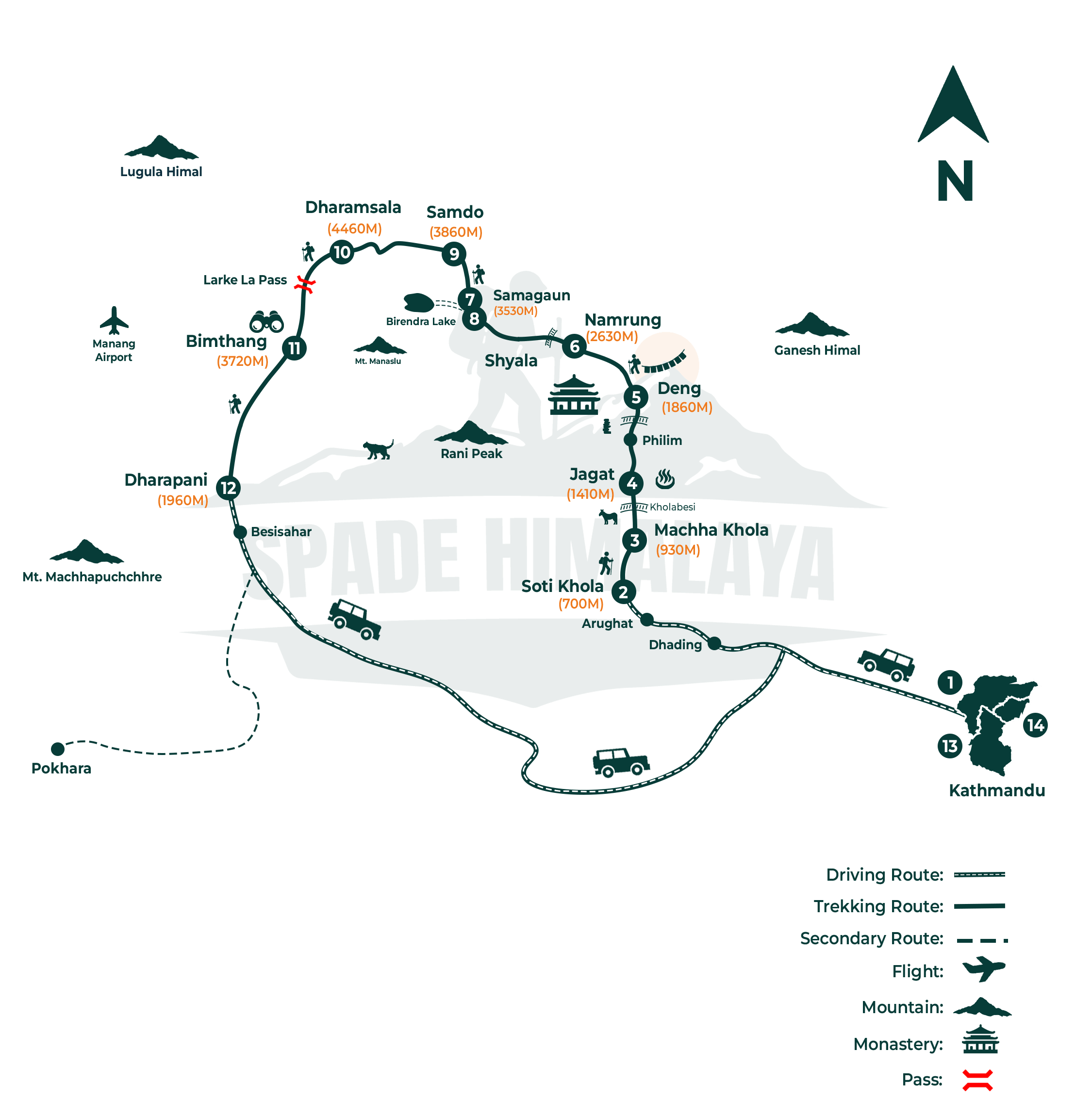
Kathmandu (1,400 m) → drive to Soti Khola (710 m) → Machha Khola (930 m) → Jagat (1,410 m) → Deng (1,860 m) → Namrung (2,630 m) → Samagaun (3,530 m) → acclimatization day → Samdo (3,860 m) → Dharmasala / Larkya Phedi (4,460 m) → Larkya La pass (5,106 m) → Bimtang (3,720 m) → Dharapani (1,960 m) → drive to Kathmandu via Besisahar.
In short, you follow the Budhi Gandaki river north and uphill from Soti Khola to Samagaun and Samdo. Then you cross the Larkya La pass into the Bimtang valley. After that, you descend west to Dharapani. There the trail meets the Annapurna Circuit and the road back to Kathmandu.
One option worth knowing about before you book. Just past Philim, a side valley branches east towards the Tibet border. That is the Tsum Valley, a Tibetan Buddhist valley that stayed closed to foreign trekkers until 2008. It has no high pass and nothing above 3,700 m, so some people walk it on its own instead of the Circuit. Others add it on and do both in around 21 to 24 days. Ask us if you would like the combined version.
Trips Itinerary
A Spade Himalaya representative meets you at Tribhuvan International Airport, helps with your bags and drives you to your hotel, around thirty minutes from the terminal.
Kathmandu sits at 1,400 m, so there is no height to manage yet. In the evening your guide runs the briefing and collects the paperwork for the restricted area permit this trek needs, so bring your passport, photographs and a copy of your insurance.
- Accommodation: 3 Star Hotel
You drive west out of Kathmandu toward Gorkha and then north along the Budhi Gandaki to the trailhead at Soti Khola, which takes seven or eight hours in all.
Soti Khola is at 710 m, so you actually drop almost 700 m from Kathmandu today. The last stretch is a rough dirt road above the river and it is slow going. The change from city to deep river valley happens in a single day, and Soti Khola is a small roadhead village with simple lodges.
- Duration: 7 to 8 hrs Drive
- Max Altitude: 710 m
- Meals: Breakfast, Lunch & Dinner
- Accommodation: Guest House
The walking starts. You climb over a ridge, cross the cliff path above the river, drop to Lapubesi and follow the Budhi Gandaki upstream to Machha Khola.
Machha Khola is at 930 m after five to seven hours, so the height gain is small. This is deliberately an easy first day that lets you find the rhythm of the trail.
The name Machha Khola means fish river. You cross several bridges and walk past sandy river banks and small farms, with the gorge walls rising steeply on both sides of you.
- Duration: 5 - 7 hrs hike
- Max Altitude: 930 m
- Meals: Breakfast, Lunch & Dinner
- Accommodation: Guest House
You follow the river north through Khorlabesi and the hot spring at Tatopani, cross to the east bank, and pass Doban and Yaru Bagar before reaching Jagat.
Jagat is at 1,410 m and the day takes five or six hours, with several short climbs and bridge crossings, so it is more up and down than the map suggests. Jagat is the entry point to the Manaslu Conservation Area and a ranger checks permits here, so keep your documents handy.
- Duration: 5 to 6 hrs Hike
- Max Altitude: 1,410 m
- Meals: Breakfast, Lunch & Dinner
- Accommodation: Guest House
A longer day climbing through Salleri, Sirdibas and the large Gurung village of Philim, then above the gorge of the Budhi Gandaki to the small settlement of Deng.
Deng is at 1,860 m after six to eight hours of walking. The gain is modest but the distance is not, and the trail spends much of the day well above the water.
At Ekle Bhatti a side trail branches off into the Tsum Valley, which is a separate trek in its own right. The country turns wilder past Philim, with waterfalls dropping straight into the gorge.
- Duration: 6 to 8 hrs walk
- Max Altitude: 1,860 m
- Meals: Breakfast, Lunch & Dinner
- Accommodation: Guest House
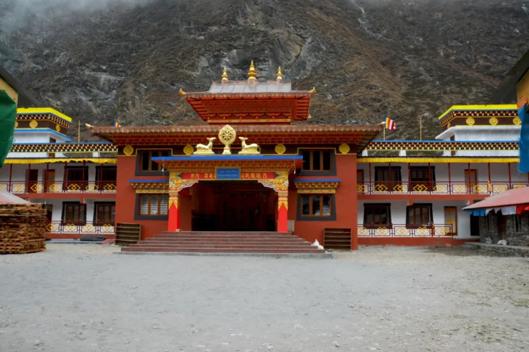
A long climbing day leads through fir and rhododendron forest, crossing the river several times on bridges, and finishes at the old trading village of Namrung.
Namrung sits at 2,630 m, so you gain nearly 800 m across seven to nine hours of walking. This is the stage where the afternoon air first turns genuinely cold on you.
Namrung was once a customs post on the salt route from Tibet, and from here the Tibetan influence in the houses, dress and Buddhist practice is clear. Langur monkeys live in this forest.
- Duration: 7 to 9 hrs walk
- Max Altitude: 2,630 m
- Meals: Breakfast, Lunch & Dinner
- Accommodation: Guest House
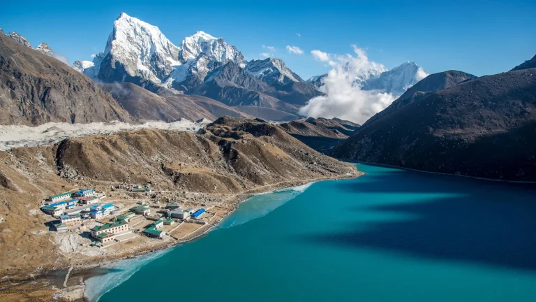
One of the best days of the trek, walking through the high villages of Lho and Shyala to Samagaun, with Manaslu itself filling the head of the valley ahead of you.
Samagaun is at 3,530 m and the day takes five to seven hours. You cross 3,000 m for the first time on this trek, so the pace slows down and the afternoon rest starts to matter.
Manaslu is 8,163 m and the eighth highest mountain in the world, and this is the first day you see it properly rather than in pieces through the trees.
The trail passes mani walls, chortens and barley fields on the way in. Samagaun is the largest village in the upper valley and you stay here two nights.
- Duration: 5 to 7 hrs walk
- Max Altitude: 3,530 m
- Meals: Breakfast, Lunch & Dinner
- Accommodation: Guest House
You stay a second night in Samagaun and spend the day walking above it, which is how your body gets ready for the pass rather than a day spent sitting still.
The main option climbs to Birendra Tal and on toward Manaslu Base Camp at around 4,800 m, then comes back down to sleep at 3,530 m. Pungyen Gompa is the gentler alternative.
Birendra Tal is a glacial lake fed straight off the Manaslu glacier and the water is an unusual milky green. From the Base Camp trail you get a close look at the icefall above it.
- Max Altitude: 3,530 m
- Meals: Breakfast, Lunch & Dinner
- Accommodation: Guest House
A short day that protects your acclimatization. You drop to the river, climb gently past the Base Camp junction, and walk through a white gateway into Samdo.
Samdo is at 3,860 m, only 330 m above Samagaun, and the walk takes six or seven hours at the deliberately slow pace this height calls for. It is the last permanent village before the pass and sits close to an old trading route into Tibet.
- Duration: 6 to 7 hrs walk
- Max Altitude: 3,860 m
- Meals: Breakfast, Lunch & Dinner
- Accommodation: Guest House
Another deliberately short stage climbs steadily toward the foot of the pass, ending at the cluster of huts called Dharmasala, which people also know as Larkya Phedi.
Dharmasala is at 4,460 m, so you gain around 600 m. It is the last shelter before the crossing and the rooms are basic, which is the point of arriving early. You walk with Manaslu and the Syacha Glacier in view, and there is a real chance of seeing blue sheep on the slopes.
- Duration: 6 - 8 hrs walk
- Max Altitude: 4,460 m
- Meals: Breakfast, Lunch & Dinner
- Accommodation: Guest House
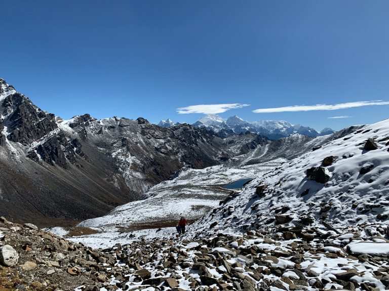
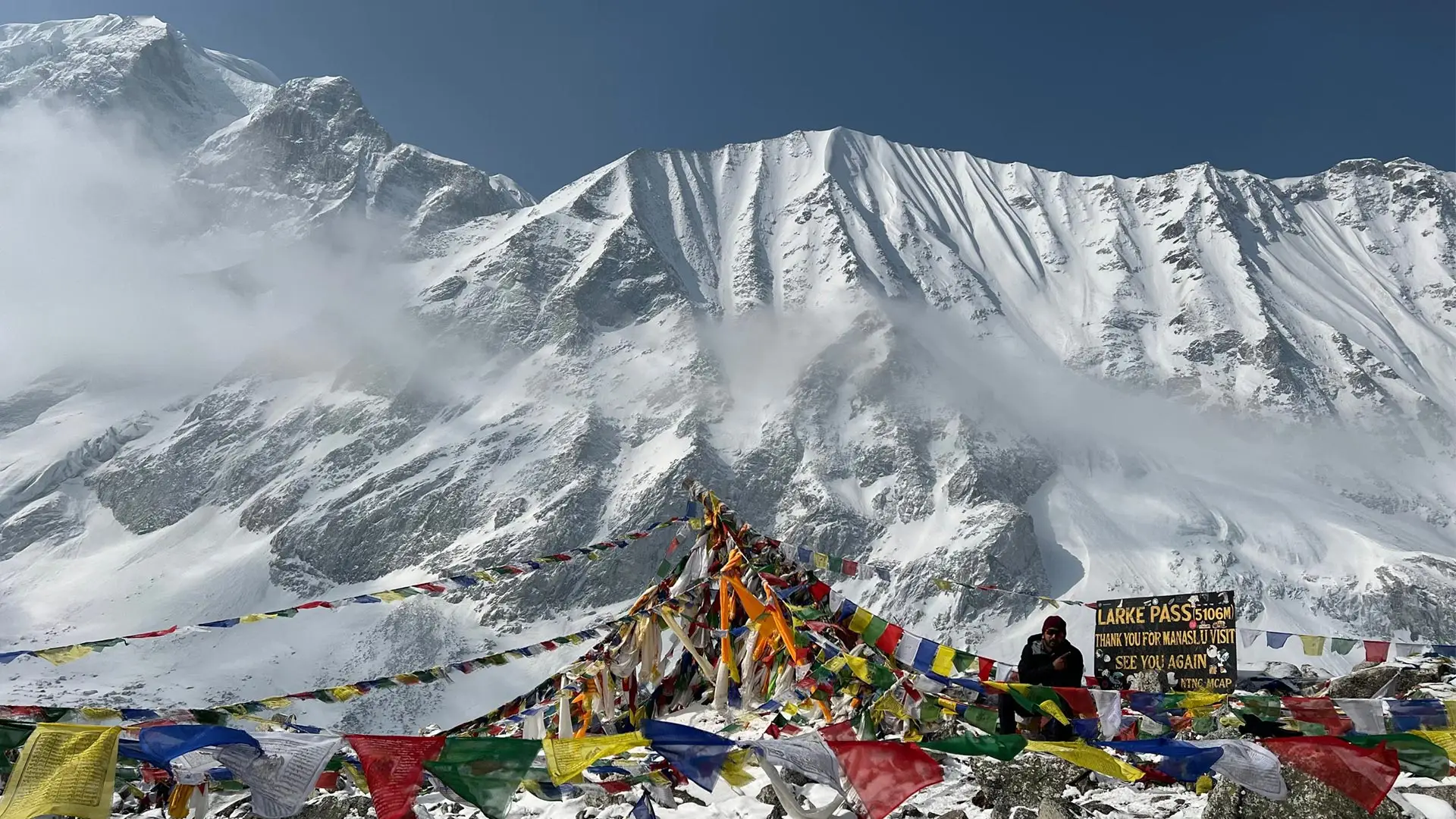
The big day. You leave before dawn, climb past frozen lakes and moraine to the prayer flags on the Larkya La, then make a long descent to the meadows at Bimtang.
The pass is 5,106 m and Bimtang is at 3,720 m, which makes seven or eight hours of walking. This is the highest and most exposed point of the whole trek.
From the top you look across Himlung Himal, Cheo Himal, Kang Guru and Annapurna II, with the Larkya glacier running away below the ridge on the far side.
Your guide checks conditions before committing to it, because fresh snow can make this crossing genuinely risky and there is no shelter on the way over.
- Duration: 7 to 8 hrs walk
- Max Altitude: 5,106 m
- Meals: Breakfast, Lunch & Dinner
- Accommodation: Guest House
A long descent below the huge face of Phungi, following the Dudh Khola down through pine forest and farmland to the villages of Gho, Tilche and finally Dharapani.
Dharapani is at 1,960 m, so you lose more than 1,700 m across six or seven hours. It is gentler ground than yesterday but the steady downhill is felt in the knees.
The stone paved Gurung villages on this side feel different again, and the warmth returns quickly as you drop. At Dharapani the trail joins the Annapurna Circuit route.
- Duration: 6 to 7 hrs walk
- Max Altitude: 1,960 m
- Meals: Breakfast, Lunch & Dinner
- Accommodation: Guest House
You leave Dharapani by shared jeep on the rough road down to Besisahar, then continue by vehicle on the highway to Kathmandu, arriving in the evening.
The jeep section takes most of the morning and the road to Kathmandu takes the rest of the day, finishing back at 1,400 m. The Himalaya shrinks behind you and the lowlands return, and Spade Himalaya hands you a trip completion certificate that evening.
- Duration: 6 - 7 hrs drive
- Max Altitude: 1,400 m
- Meals: Breakfast Included
- Accommodation: Star Hotel
Your trip ends today. After breakfast a representative drives you to the airport, roughly thirty minutes away though traffic can stretch it, and we suggest arriving about three hours before your flight. We can arrange extra nights or a Chitwan extension if you ask in advance.
- Meals: Breakfast Included
Trips Include
- Airport transfers in a private vehicle.
- 2 nights' hotel in Kathmandu (arrival and post-trek).
- .Kathmandu to Soti Khola transport (local bus or shared jeep) and Dharapani to Besisahar to Kathmandu return transport.
- All teahouse and lodge accommodation during the trek.
- All meals (breakfast, lunch, dinner) during the trek.
- Manaslu Restricted Area Permit, Manaslu Conservation Area Permit (MCAP), and Annapurna Conservation Area Permit (ACAP).
- A licensed guide, experienced English-speaking.
- All government and local taxes and official paperwork.
Trips Exclude
- International airfare to and from Nepal.
- Nepal entry visa.
- Travel and medical insurance.
- Lunches and dinners in Kathmandu.
- Drinks, bottled water, snacks, and desserts on the trail.
- Hot showers, Wi-Fi, and device charging at teahouses.
- Tips for guide, porters, and drivers.
- Personal expenses and any costs arising from early departure due to illness or other reasons.
- Anything not listed under Cost Includes.
Trips Altitude
Trips Map
Packing List
General
- Four-season (zero degree) sleeping bag (provided by Spade Himalaya for use, returned after the trek)
- Sleeping bag liner
- Puffy down jacket (provided by Spade Himalaya for use, returned after the trek)
- Duffel bag (provided by Spade Himalaya, carried by the porter, returned after the trek)
- Daypack, 30 to 45 litres, with a rain cover
Upper Body
- Warm hat or beanie that covers the ears
- Neck gaiter, buff, or scarf
- Sunglasses with UV protection
- Headlamp with spare batteries
- Sunscreen (SPF 35 to 60) and lip balm
- Technical base-layer tops (long and short sleeve)
- Fleece jacket or wool pullover
- Waterproof, windproof shell jacket
Lower Body
- Thermal base-layer trousers
- Comfortable trekking trousers
- Casual or sport trousers for the teahouses
- Waterproof, windproof shell trousers
Hands
- Wool or technical liner gloves
- Insulated shell outer gloves
- Light gloves for using walking poles (optional)
Feet
- Waterproof trekking boots (well broken in)
- 4 to 5 pairs of warm wool socks and sock liners
- Light shoes or sandals for the evenings
- Micro spikes or instep crampons (useful if there is snow on the pass)
Undergarments
- Quick-drying technical underwear
- Thermal underwear set for cold nights
First Aid Kits
Your guide carries a kit, medication, and a pulse oximeter, but a personal kit is strongly recommended.
- Assorted adhesive and butterfly bandages
- Blister treatment cream and antiseptic ointment
- Ibuprofen or other pain relief
- Altitude medication such as acetazolamide (Diamox), only if advised by your doctor
- Insect or anti-itch ointment
- Water-purification tablets
Others
- Passport, 4 passport-size photos, and a copy of your insurance and flight details
- Reusable water bottle and a water filter or purifier
- Toiletry kit, quick-dry towel, toilet paper, hand wipes, and soap
- High-energy snacks (bars, nuts, dried fruit)
- Waterproof or dry bags for documents and electronics
Optional
- Trekking poles (your own, if you prefer them; otherwise provided)
- Power bank and spare batteries
- Camera with memory cards, charger, and spare batteries
- Music player and earphones
Good to Know
Before you go
You only need a few things ready. First, bring your passport, four photos, and a copy of your insurance. Then Spade Himalaya can sort your RAP, MCAP, and ACAP. The restricted-area permit is only issued through a registered agency, even for solo trekkers. Since March 2026, it also uses an online, pre-arrival system, so we can start yours before you land (Kathmandu Post, 2026). Also, carry enough cash in Nepalese rupees from Kathmandu, because there are no ATMs on the trail. Last, train before you come, because the pass day is long.
Manaslu has required a licensed guide far longer than Nepal’s general regions. As a restricted area near the Tibet border, it can only be trekked with a licensed guide and a permit from a registered agency. The March 2026 update eased the old two-person minimum. But it kept the licensed-guide and registered-agency rules firmly in place (The Himalayan Times, 2026). Spade Himalaya is a registered agency with licensed guides. So your permits, plans, and emergency cover are handled end to end.
The plan follows the climb-high, sleep-low rule. So it adds a rest day at Samagaun and short stages to Samdo and Dharmasala before the pass. Drink 3 to 4 litres of water a day, walk slowly, and skip alcohol up high. Tell your guide early if you feel unwell. Carry altitude medicine only if your doctor advises it. Going down is the best cure, and your guide will make that call fast if needed.
You sleep in simple teahouses with twin rooms. Higher up, rooms are basic and nights are cold, so the sleeping bag matters. The food is filling: dal bhat, noodles, potatoes, soup, and bread. Vegetarian meals are easy, and meat is best avoided up high. For water, refill and purify rather than buy bottles. Snow can close the Larkya La from about mid-December to mid-March, so micro spikes help in the shoulder seasons, and your guide always checks the pass first.
Trips Reviews
A Remote Himalayan Adventure That Exceeded Every Expectation
Trips FAQs
Trek Difficulty: Who Can Trek?
It is graded moderate to strenuous. There is no climbing skill needed. Still, you walk 5 to 7 hours a day for about two weeks, and you cross the Larkya La pass at 5,106 m. The thin air and the long pass day are the main challenges, not the trail. So anyone reasonably fit who trains and acclimatizes can finish it at a guided pace.
The Larkya La sits at 5,106 m, and it is one of the longest passes in the Nepal Himalaya (Wikipedia, 2026). The crossing is the toughest day. You start before dawn, climb over moraine and snow, then drop steeply to Bimtang. In all, it takes 7 to 9 hours. Your guide checks the conditions first and turns back if the pass is unsafe.
Guide Requirement & Trek Regulations
Yes. Manaslu is a restricted area, and the law requires a licensed guide for every trekker. The March 2026 rule lets solo travellers apply for a permit on their own. But they still must trek with a licensed guide from a registered agency (Kathmandu Post, 2026). So you cannot walk it alone. That is part of why it stays so quiet.
Permits and Entry Requirements
You need three. First, the Manaslu Restricted Area Permit (RAP). Second, the Manaslu Conservation Area Permit (MCAP). Third, the Annapurna Conservation Area Permit (ACAP). The RAP costs US$100 per person for the first 7 days in September to November, and US$75 in December to August, plus a daily fee after that (Nepal Department of Immigration, 2026). MCAP and ACAP are about NPR 3,000 each. Spade Himalaya arranges all three.
Because the circuit ends at Dharapani, inside the Annapurna Conservation Area. The last two days and the descent toward Besisahar pass through Annapurna land. So an ACAP is needed on top of the Manaslu permits. Want to extend your trip? The same valley is the start of the Annapurna Circuit Trek.
Best Time to Trek the Manaslu Circuit
Spring (March to May) and autumn (mid-September to November) are best, with stable weather and an open pass. October is the busiest and clearest month. Winter is cold, and snow can block the Larkya La. The summer monsoon brings rain and leeches low down. For winter on a connected route, see our Annapurna Circuit winter guide.
Trekker's Well-Being & Safety
The risk rises above about 3,000 m and grows the higher you go. So the plan adds a rest day at Samagaun and gentle climbs to Samdo and Dharmasala. Your guide also checks your oxygen twice a day with an oximeter. Drink 3 to 4 litres of water daily, skip alcohol, and go down early if symptoms appear. These steps keep the risk low.
Yes, it is a must. Your policy has to cover trekking up to 5,500 m and a helicopter rescue. Many normal policies do not, so check the wording first. Arrange it at home before you fly. Then leave a copy with Spade Himalaya at the briefing, so the team can act fast in an emergency.